


circuit 4

Guy Laurent
User
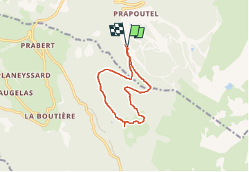

Length
5.9 km

Max alt
1539 m

Uphill gradient
250 m
Km-Effort
9.3 km

Min alt
1295 m

Downhill gradient
257 m
Boucle
Yes
Creation date :
2025-01-22 13:13:32.159
Updated on :
2025-01-22 15:10:44.551
1h56
Difficulty : Medium

FREE GPS app for hiking
 SityTrail
IGN / Geographical institutes
SityTrail Plus
The world is yours!
About
Trail Walking of 5.9 km to be discovered at Auvergne-Rhône-Alpes, Isère, Les Adrets. This trail is proposed by Guy Laurent.
Description
marche et/ou raquette
Positioning
Country:
France
Region :
Auvergne-Rhône-Alpes
Department/Province :
Isère
Municipality :
Les Adrets
Location:
Unknown
Start:(Dec)
Start:(UTM)
734894 ; 5015173 (31T) N.
Comments